Dec 27, 2022
2 min read
OpenStreetMap presentation to Institute of Crisis Management Studies

Sazal Sthapit
Socio-Tech Manager
The former socio tech manager at KLL, Sazal is currently pursuing his Masters of Information Science at Syracuse University.
“A large population in Nepal faces disaster every year. Disaster is inherently tied to location” – Dr. Nama Raj Budhathoki in his talk at Institute of Crisis Management Studies.
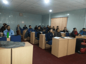
Different organizations have been using OpenStreetMap in organizing and coordinating relief efforts. Haiti earthquake and Philippines typhoon are two such cases where OpenStreetMap was used to improve the map of the crisis affected areas and to coordinate the relief efforts. These examples point to cases of natural disasters. But disasters are not always natural phenomena; disasters can be political, economic, societal or environmental. OpenStreetMap can be, and has been, used in disaster preparedness and recovery efforts. Our talk to students from Institute of Crisis Management Studies (ICMS) on 13th February 2014 was along this line.
The attendees, a class of twenty students, were professionals from diverse backgrounds and work areas: officers from Nepal Army and Armed Police Force, political leaders affiliated to different political parties, humanitarian workers.

Contributing to the discussion, students put forward genuine concerns - Can everyone upload data to OSM? What is the checkback system if anyone puts wrong data on the map? What was fascinating was how quickly one of the lady army officials in the class internalized the whole concept and very confidently said, “This is indeed democratization of data.” “OpenStreetMap can be used to plan evacuation routes, find open spaces,” quipped another participant. Read ICMS's blog on the event here.
The discussion ended with a vote of thanks by Dr. Ram Thapaliya, President, ICMS.
Disaster is a persistent threat to community. And it’s high time we develop crisis management leadership and build local capacity to gather critical infrastructure data and use this data to mitigate risk and aid disaster response. We congratulate the ICMS team for giving a shape to this idea of responding to challenges brought by both natural and man-made disasters in Nepal. We understand that based on our current data coverage in OpenStreetMap, it is time to develop and enact clear strategies for using OpenStreetMap whenever and wherever required.

Sazal Sthapit
Socio-Tech Manager
The former socio tech manager at KLL, Sazal is currently pursuing his Masters of Information Science at Syracuse University.
Read More from our Blog
Subscribe to our Newsletter
Contact Details
1474 Lamtangin Marg, Chundevi
+977-1-4720136
contact@kathmandulivinglabs.org
Copyright 2023. Kathmandu Living Labs. All Rights Reserved